Panama declared a nationwide state of emergency after two powerful earthquakes, measured at magnitudes 7.7 and 6.6, struck hours apart and injured dozens, damaged hundreds of buildings, and forced evacuations, according to official records and major outlets.
Story Highlights
- Two strong quakes, 7.7 and 6.6, hit central Panama hours apart on October 9, 2026.
- Government declared a state of emergency to coordinate relief for hard-hit areas.
- News outlets reported at least 27 injuries and damage to hundreds of buildings.
- Aftershocks and evacuations continued as authorities assessed structural risks.
What happened and where shaking was strongest
United States Geological Survey (USGS) records show a magnitude-7.7 earthquake struck near Pitaloza Arriba at 17:56:06 Coordinated Universal Time on October 9, followed by a magnitude-6.6 event near Río Grande at 20:25:39 Coordinated Universal Time the same day. The USGS assigned very strong to severe shaking levels for parts of the region. The first quake hit around early afternoon local time, with the second occurring roughly three hours later as communities were still reacting.
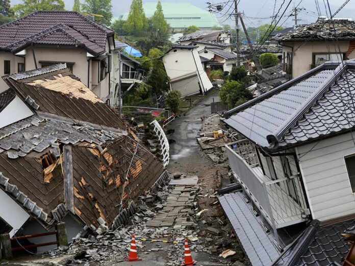
Local and international news outlets described toppled buildings near the epicenter, damaged roads, and hurried evacuations from public and private structures. Reporters in Spanish-language coverage counted at least 27 people with minor injuries and damage to hundreds of buildings, including homes, businesses, and government facilities. Images and video showed dust, cracked walls, and people moving to open spaces. Authorities warned that aftershocks could further weaken already stressed structures as assessments continued.
Why Panama declared a state of emergency
Presidential Minister Juan Carlos Orillac announced a state of emergency at a news conference in Panama City on Saturday, October 10, to speed aid and coordinate the response for affected provinces. The emergency declaration aimed to organize rescue, medical help, debris removal, and temporary shelter while engineers inspected critical infrastructure. Reports also noted continuing aftershocks, which raised safety risks for search and inspection teams and for residents returning to homes and workplaces. The step tracks with common disaster practice when damage spans many communities.
Emergency declarations unlock tools for faster government action. They can allow quick spending, faster contracting, and mutual aid. They can also centralize command so decisions are clearer and faster. In fast-moving crises like major earthquakes, that can save lives. At the same time, officials often face pressure to show results quickly, even as the picture of damage changes hour by hour. That is why early numbers on injuries, closures, and costs often shift as teams reach more remote areas.
How agencies measure quakes and why numbers can shift
The United States Geological Survey’s Earthquake Hazards Program compiles rapid estimates and then refines them as more data arrive from stations worldwide. Magnitudes can be revised as models update, which explains why some outlets described the main event as 7.5 while USGS lists 7.7 for the final reviewed solution. That difference does not mean the event was small. Both values signal a major quake capable of heavy damage near the epicenter. USGS also generates shaking intensity maps that help responders target inspections.
Classifying the second 6.6 event as an aftershock depends on sequence analysis that weighs time, location, and fault mechanics. News coverage called it an aftershock, but the technical label rests with seismologists who review the sequence with more data. What matters for public safety is that strong events in the same area can hit weakened buildings. People are right to stay cautious, heed local guidance, and avoid reentering visibly damaged structures until cleared by inspectors.
Why this matters to Americans watching from afar
Earthquakes abroad still hit home for the United States. Americans live, work, and travel in Panama. Supply chains and shipping routes connect through the region. When quakes damage roads, bridges, or power, trade can slow and prices can rise. United States emergency managers also study foreign events to improve building codes, warning systems, and public alerts here. The USGS tools used for Panama also support American readiness and help local leaders plan drills and retrofits.
For readers who feel federal systems are slow or favor the well connected, disaster response often looks like a stress test. Clear numbers and steady updates build trust. Mixed figures and missing documents can do the opposite. In Panama, the big facts are firm: two strong quakes, real damage, and a government move to coordinate help. As officials refine counts and timelines, the public will judge by simple results: safe water, open roads, working clinics, and honest reports of what broke and what got fixed.
Sources:
youtube.com, ajc.com, usgs.gov, bbc.com, english.news.cn